Gulf Coast of the United States: Difference between revisions
ToadetteEdit (talk | contribs) →Geography: Fixing bare URLs 2 Tags: Mobile edit Mobile app edit Android app edit |
SPARTAN6303 (talk | contribs) Replaced Navarre with Panama City on list of large cities in intro, as Panama City is the center of its metro and has a port, while Navarre is an unincorporated community within the Pensacola Metro |
||
| (7 intermediate revisions by 4 users not shown) | |||
| Line 1: | Line 1: | ||
{{Redirect|Gulf Coast|other uses|Gulf Coast (disambiguation)}} |
{{Redirect|Gulf Coast|other uses|Gulf Coast (disambiguation)}} |
||
{{Use American English|date |
{{Use American English|date=November 2023}} |
||
{{Use mdy dates|date |
{{Use mdy dates|date=November 2023}} |
||
{{Infobox settlement |
{{Infobox settlement |
||
| name = Gulf Coast |
| name = Gulf Coast |
||
| Line 274: | Line 274: | ||
The '''Gulf Coast of the United States''', also known as the '''Gulf South''' or the '''South Coast''', is the [[coast|coastline]] along the [[Southern United States]] where they meet the [[Gulf of Mexico]]. The [[list of U.S. states and territories by coastline|coastal states]] that have a [[shore|shoreline]] on the Gulf of Mexico are [[Texas]], [[Louisiana]], [[Mississippi]], [[Alabama]], and [[Florida]], and these are known as the ''Gulf States''.<ref>For example: {{Cite web|url=https://www.lsu.edu/ces/publications/2017/GCEO2017.pdf|title=Gulf Coast Energy Outlook|publisher=Center for Energy Studies|via=Economics & Policy Research Group|archive-url=https://web.archive.org/web/20180414031817/https://www.lsu.edu/ces/publications/2017/GCEO2017.pdf|archive-date=14 April 2018|access-date=13 Apr 2018|edition=Spring 2017}}, p. 1 (" Unless stated otherwise, Gulf Coast hereafter specifically refers to the states of Texas, Louisiana, Mississippi, Alabama, and Florida").</ref> |
The '''Gulf Coast of the United States''', also known as the '''Gulf South''' or the '''South Coast''', is the [[coast|coastline]] along the [[Southern United States]] where they meet the [[Gulf of Mexico]]. The [[list of U.S. states and territories by coastline|coastal states]] that have a [[shore|shoreline]] on the Gulf of Mexico are [[Texas]], [[Louisiana]], [[Mississippi]], [[Alabama]], and [[Florida]], and these are known as the ''Gulf States''.<ref>For example: {{Cite web|url=https://www.lsu.edu/ces/publications/2017/GCEO2017.pdf|title=Gulf Coast Energy Outlook|publisher=Center for Energy Studies|via=Economics & Policy Research Group|archive-url=https://web.archive.org/web/20180414031817/https://www.lsu.edu/ces/publications/2017/GCEO2017.pdf|archive-date=14 April 2018|access-date=13 Apr 2018|edition=Spring 2017}}, p. 1 (" Unless stated otherwise, Gulf Coast hereafter specifically refers to the states of Texas, Louisiana, Mississippi, Alabama, and Florida").</ref> |
||
The economy of the Gulf Coast area is dominated by industries related to energy, petrochemicals, fishing, aerospace, agriculture, and tourism. The large cities of the region are (from west to east) [[Brownsville, Texas|Brownsville]], [[Corpus Christi, Texas|Corpus Christi]], [[Houston]], [[Galveston, Texas|Galveston]], [[Beaumont, Texas|Beaumont]], [[Lake Charles, Louisiana|Lake Charles]], [[Lafayette, Louisiana|Lafayette]], [[Baton Rouge, Louisiana|Baton Rouge]], [[New Orleans]], [[Gulfport, Mississippi|Gulfport]], [[Biloxi, Mississippi|Biloxi]], [[Mobile, Alabama|Mobile]], [[Pensacola, Florida|Pensacola]], [[ |
The economy of the Gulf Coast area is dominated by industries related to energy, petrochemicals, fishing, aerospace, agriculture, and tourism. The large cities of the region are (from west to east) [[Brownsville, Texas|Brownsville]], [[Corpus Christi, Texas|Corpus Christi]], [[Houston]], [[Galveston, Texas|Galveston]], [[Beaumont, Texas|Beaumont]], [[Lake Charles, Louisiana|Lake Charles]], [[Lafayette, Louisiana|Lafayette]], [[Baton Rouge, Louisiana|Baton Rouge]], [[New Orleans]], [[Gulfport, Mississippi|Gulfport]], [[Biloxi, Mississippi|Biloxi]], [[Mobile, Alabama|Mobile]], [[Pensacola, Florida|Pensacola]], [[Panama City, Florida|Panama City]], [[St. Petersburg, Florida|St. Petersburg]], and [[Tampa, Florida|Tampa]]. All are the centers or major cities of their respective [[metropolitan area]]s and many of which contain large [[port]]s. |
||
==Geography== |
==Geography== |
||
[[File:Aerial views of the Houston, Texas, skyline in 2014 LCCN2014632225.tif|thumb|Houston is the largest city and urban area along the Gulf Coast]] |
[[File:Aerial views of the Houston, Texas, skyline in 2014 LCCN2014632225.tif|thumb|[[Houston]] is the largest city and urban area along the Gulf Coast]] |
||
The Gulf Coast is made of many [[inlets]], [[bays]], and [[lagoons]]. The coast is intersected by numerous rivers, the largest of which is the [[Mississippi River]]. Much of the land along the Gulf Coast is, or was, [[marsh]]land.<ref>{{Cite web|date=2014-01-08|title=Gulf Coast Wetlands Rapidly Declining • The National Wildlife Federation Blog|url=https://blog.nwf.org/2014/01/gulf-coast-wetlands-rapidly-declining/|access-date=2021-03-04|website=The National Wildlife Federation Blog|language=en-US}}</ref> Ringing the Gulf Coast is the [[Gulf Coastal Plain]], which reaches from [[Southern Texas]] to the western [[Florida Panhandle]], while the western portions of the Gulf Coast are made up of many [[barrier island]]s and [[peninsula]]s, including the {{convert|130|mi|km|adj=on}} [[Padre Island]] along the Texas coast. These landforms protect numerous [[bay]]s and [[inlet]]s providing as a barrier to oncoming waves. The central part of the Gulf Coast, from eastern Texas through Louisiana, consists primarily of marshland. The eastern part of the Gulf Coast, predominantly Florida, is dotted with many bays and inlets. |
The Gulf Coast is made of many [[inlets]], [[bays]], and [[lagoons]]. The coast is intersected by numerous rivers, the largest of which is the [[Mississippi River]]. Much of the land along the Gulf Coast is, or was, [[marsh]]land.<ref>{{Cite web|date=2014-01-08|title=Gulf Coast Wetlands Rapidly Declining • The National Wildlife Federation Blog|url=https://blog.nwf.org/2014/01/gulf-coast-wetlands-rapidly-declining/|access-date=2021-03-04|website=The National Wildlife Federation Blog|language=en-US}}</ref> Ringing the Gulf Coast is the [[Gulf Coastal Plain]], which reaches from [[Southern Texas]] to the western [[Florida Panhandle]], while the western portions of the Gulf Coast are made up of many [[barrier island]]s and [[peninsula]]s, including the {{convert|130|mi|km|adj=on}} [[Padre Island]] along the Texas coast. These landforms protect numerous [[bay]]s and [[inlet]]s providing as a barrier to oncoming waves. The central part of the Gulf Coast, from eastern Texas through Louisiana, consists primarily of marshland. The eastern part of the Gulf Coast, predominantly Florida, is dotted with many bays and inlets. |
||
===Climate=== |
===Climate=== |
||
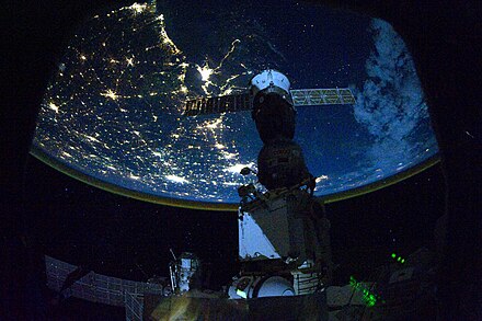
[[File:ISS Expedition 25 Night Time Image Of The US Northern Gulf Coast.jpg|thumb|Night time astronaut image of the northern Gulf coast |
[[File:ISS Expedition 25 Night Time Image Of The US Northern Gulf Coast.jpg|thumb|Night time astronaut image of the northern Gulf coast]] |
||
The Gulf Coast climate is humid subtropical, although [[Southwest Florida]] features a tropical climate. Much of the year is warm to hot along the Gulf Coast, while the three winter months bring periods of cool (or rarely, cold) weather mixed with mild temperatures. The area is highly vulnerable to [[tropical cyclone|hurricanes]] as well as [[flood]]s and severe [[thunderstorm]]s. Much of the Gulf Coast has a summer precipitation maximum, with July or August commonly the wettest month due to the combination of frequent summer thunderstorms produced by relentless heat and humidity, and tropical weather systems |
The Gulf Coast climate is humid subtropical, although [[Southwest Florida]] features a tropical climate. Much of the year is warm to hot along the Gulf Coast, while the three winter months bring periods of cool (or rarely, cold) weather mixed with mild temperatures. The area is highly vulnerable to [[tropical cyclone|hurricanes]] as well as [[flood]]s and severe [[thunderstorm]]s. Much of the Gulf Coast has a summer precipitation maximum, with July or August commonly the wettest month due to the combination of frequent summer thunderstorms produced by relentless heat and humidity, and tropical weather systems, including tropical depressions, tropical storms, and [[hurricanes]], while winter and early spring rainfall also can be heavy. |
||
This pattern is evident in southern cites as [[Houston]], [[New Orleans]], [[Mobile, Alabama]], and [[Pensacola, Florida]]. However, the central and southern [[Florida]] peninsula and [[South Texas]] has a pronounced winter dry season, as at [[Tampa, Florida|Tampa]] and [[Fort Myers, Florida|Fort Myers]]. On the central and southern Texas coast, winter, early spring and mid-summer are markedly drier, and September is the wettest month on average at [[Corpus Christi, Texas|Corpus Christi]] and [[Brownsville, Texas]]. [[Tornado]]es are infrequent at the coast but do occur; however, they occur more frequently in inland portions of Gulf Coast states. Over most of the Gulf Coast from [[Houston, Texas]], eastward, extreme rainfall events are a significant threat, commonly from tropical weather systems, which can bring 4 to 10 or more inches of rain in a single day. In August 2017, [[Hurricane Harvey]] made landfall along the central Texas coast, then migrated to and stalled over the greater [[Houston]] area for several days, producing extreme, unprecedented rainfall totals of over 40 inches (1,000 mm) in many areas, unleashing widespread flooding. Climate scientists predict more hurricanes for Florida<ref>See "Projected change in U.S. hurricane risk based on Risk Analysis Framework for Tropical Cyclones (RAFT)." Fig. 1 ''op cit''</ref> and the Texas coastline in particular.<ref>Karthik Balaguru ''et al.'' , "Increased U.S. coastal hurricane risk under climate change." ''Science Advances''. 9,(2023). 14. DOI:10.1126/sciadv.adf0259. [https://www.science.org/doi/full/10.1126/sciadv.adf0259 Science.org website] Retrieved 17 Aug 2023.</ref> [[Earthquakes]] are extremely rare to the area, but a [[2006 Gulf of Mexico earthquake|6.0 earthquake]] in the Gulf of Mexico on September 10, 2006, could be felt from the cities of New Orleans to Tampa. |
|||
===Rising sea levels=== |
===Rising sea levels=== |
||
Due to the release of greenhouse gas emissions, glaciers and ice sheets are melting and expanding the oceans. |
Due to the release of greenhouse gas emissions, glaciers and ice sheets are melting and expanding the oceans. The United States coastlines are projected to rise 1 foot in three decades or between 10 and 12 inches on average by 2050.<ref name="ToriCBS">{{cite news|date=2022-02-19|url= |
||
https://www.cbsnews.com/news/sea-level-rise-2050-study/|title=Sea levels along U.S. coastlines to rise more than a foot by 2050, study projects|last=B. Powell |first=Tori|work=CBS News|accessdate=2023-08-30}}</ref> The Gulf Coast will likely see the biggest change, with sea levels expected to rise between 14 and 18 inches. The Global and Regional Sea Level Rise Report predicted more frequent, major and destructive high tide flooding events along with taller storm surges by 2050 after scientists determined high tide flooding has been "increasingly common" over the past few years due to the rising sea levels.<ref name=ToriCBS /> The impacts are expected to be dramatic. Low-lying coastal areas are expected to experience multiple factors, including increased levels of flooding, accelerated erosion, loss of wetlands and low-lying terrestrial ecosystems, and seawater intrusion into freshwater sources. Rising sea level and erosion will also imperil critical habitats for many commercially important fisheries that depend on inshore waters for either permanent residence or nursery area.<ref>{{cite web|url=https://coastalscience.noaa.gov/project/predicting-impacts-sea-level-rise-gulf-mexico/|title=Predicting Impacts of Sea Level Rise in the Northern Gulf of Mexico|work=coastalscience.noaa.gov|accessdate=2023-08-30}}</ref> In 2021 alone rising sea levels cost the United States approximately $2.6 billion in relief efforts and caused at least seven deaths.<ref name=ToriCBS /> By 2051, the cost of flood damage is expected to increase by 61%, or $32 billion.<ref>{{cite news|url= |
|||
https://abcnews.go.com/US/climate-change-rising-sea-levels-increase-cost-flood/story?id=76044769|title=Climate change, rising sea levels to increase cost of flood damage by $34 billion in coming decades: Report |
https://abcnews.go.com/US/climate-change-rising-sea-levels-increase-cost-flood/story?id=76044769|title=Climate change, rising sea levels to increase cost of flood damage by $34 billion in coming decades: Report |
||
|work=ABC News|date=2021-02-22|last=Jacobo|first=Julia|accessdate=2023-08-30}}</ref> |
|work=ABC News|date=2021-02-22|last=Jacobo|first=Julia|accessdate=2023-08-30}}</ref> |
||
<ref> |
|||
https://www.cbsnews.com/news/sea-level-rise-2050-study/</ref> |
|||
<ref>https://coastalscience.noaa.gov/project/predicting-impacts-sea-level-rise-gulf-mexico/ </ref> |
|||
==Economic activities== |
==Economic activities== |
||
| Line 309: | Line 309: | ||
==History== |
==History== |
||
[[File:United States 1803-04-1804-03.png|thumb|Map of the [[Louisiana Purchase]]]] |
[[File:United States 1803-04-1804-03.png|thumb|Map of the [[Louisiana Purchase]]]] |
||
[[Hurricane Katrina]] and [[Hurricane Rita]] have destroyed a number of museums and archives in the Gulf Coast. In 2008 floods in Iowa destroyed the local ''Flood Museum'' which held materials from the [[Great Mississippi and Missouri Rivers Flood of 1993]].<ref>{{cite book | author1=Sarah S. Brophy| author2= Elizabeth Wylie |title=The Green Museum: A Primer on Environmental Practice |publisher= Bloomsbury Publishing |year=2013 |page=7 |isbn=9780759123229 }}</ref> |
|||
Before European settlers arrived in the region, the Gulf Coast was home to several pre-Columbian kingdoms which had extensive trade networks with empires such as the Aztecs and the Mississippi Mound Builders. Shark and alligator teeth and shells from the Gulf have been found as far north as Ohio, in the mounds of the Hopewell culture.<ref>Nash, Gary B. ''Red, White and Black: The Peoples of Early North America'' Los Angeles 2015 |
Before European settlers arrived in the region, the Gulf Coast was home to several pre-Columbian kingdoms which had extensive trade networks with empires such as the Aztecs and the Mississippi Mound Builders. Shark and alligator teeth and shells from the Gulf have been found as far north as Ohio, in the mounds of the Hopewell culture.<ref>Nash, Gary B. ''Red, White and Black: The Peoples of Early North America'' Los Angeles 2015 p. 6</ref> |
||
The first Europeans to settle the Gulf Coast were primarily the [[French Colonial Empire|French]] and the [[Spanish Empire|Spanish]]. The [[Louisiana Purchase]] (1803), [[Adams–Onís Treaty]] (1819) and the [[Texas Revolution]] (1835-1836) made the Gulf Coast a part of the United States during the first half of the 19th century. As the U.S. population continued to expand its frontiers westward, the Gulf Coast was a natural magnet in the [[American South|South]] providing access to shipping lanes and both national and international commerce. The development of [[sugar]] and [[cotton]] production (enabled by [[Slavery in the United States|slavery]]) allowed the South to prosper. By the mid 19th century the city of [[New Orleans]], being situated as a key to commerce on the [[Mississippi River]] and in the Gulf, had become the largest U.S. city not on the [[East Coast of the United States|Atlantic seaboard]] and the fourth largest in the U.S. overall. |
The first Europeans to settle the Gulf Coast were primarily the [[French Colonial Empire|French]] and the [[Spanish Empire|Spanish]]. The [[Louisiana Purchase]] (1803), [[Adams–Onís Treaty]] (1819) and the [[Texas Revolution]] (1835-1836) made the Gulf Coast a part of the United States during the first half of the 19th century. As the U.S. population continued to expand its frontiers westward, the Gulf Coast was a natural magnet in the [[American South|South]] providing access to shipping lanes and both national and international commerce. The development of [[sugar]] and [[cotton]] production (enabled by [[Slavery in the United States|slavery]]) allowed the South to prosper. By the mid 19th century the city of [[New Orleans]], being situated as a key to commerce on the [[Mississippi River]] and in the Gulf, had become the largest U.S. city not on the [[East Coast of the United States|Atlantic seaboard]] and the fourth largest in the U.S. overall. |
||
Two major events were turning points in the earlier history of the Gulf Coast region. The first was the [[American Civil War]], which caused severe damage to some economic sectors in the [[American South|South]], including the Gulf Coast. The second event was the [[Galveston Hurricane of 1900]]. At the end of the 19th century [[Galveston]] was, with New Orleans, one of the most developed cities in the region. The city had the third busiest port in the U.S.<ref name="Txfacts">{{cite web |url= http://www.1900storm.com/isaaccline/isaacsstorm.lasso |title= The 1900 Storm |access-date= 2006-07-11 |url-status= dead |archive-url= https://web.archive.org/web/20060711063120/http://www.1900storm.com/isaaccline/isaacsstorm.lasso |archive-date= 2006-07-11 }}</ref> and its financial district was known as the "Wall Street of the South".<ref name="GALVESTON.COM">{{cite web |
Two major events were turning points in the earlier history of the Gulf Coast region. The first was the [[American Civil War]], which caused severe damage to some economic sectors in the [[American South|South]], including the Gulf Coast. The second event was the [[Galveston Hurricane of 1900]]. At the end of the 19th century [[Galveston]] was, with New Orleans, one of the most developed cities in the region. The city had the third busiest port in the U.S.<ref name="Txfacts">{{cite web |url= http://www.1900storm.com/isaaccline/isaacsstorm.lasso |title= The 1900 Storm |access-date= 2006-07-11 |url-status= dead |archive-url= https://web.archive.org/web/20060711063120/http://www.1900storm.com/isaaccline/isaacsstorm.lasso |archive-date= 2006-07-11 }}</ref> and its financial district was known as the "Wall Street of the South".<ref name="GALVESTON.COM">{{cite web |url=http://www.galveston.com/history |title=Galveston, Texas History |access-date=2007-10-15 |publisher=Galveston.com}}</ref> |
||
|url=http://www.galveston.com/history |
|||
|title=Galveston, Texas History |
|||
|access-date=2007-10-15 |
|||
|work=Galveston.com |
|||
}}</ref> The storm mostly destroyed the city, which has never regained its former glory, and set back development in the region. |
|||
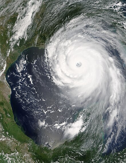
[[File:Hurricane Katrina August 28 2005 NASA.jpg|thumb|[[Hurricane Katrina]]]] |
[[File:Hurricane Katrina August 28 2005 NASA.jpg|thumb|[[Hurricane Katrina]]]] |
||
Since then the Gulf Coast has been hit with numerous other hurricanes. |
Since then the Gulf Coast has been hit with numerous other hurricanes. On August 29, 2005, [[Hurricane Katrina]] struck the Gulf Coast as a [[Saffir–Simpson Hurricane Scale#Category 3|Category 3]] hurricane. It was the [[List of costliest Atlantic hurricanes|most damaging storm]] in the history of the United States, causing upwards of $80 billion in damages, and leaving over 1,800 dead. Again in 2008 the Gulf Coast was struck by a catastrophic hurricane. Due to its immense size, [[Hurricane Ike]] caused devastation from the [[Louisiana]] coastline all the way to the [[Kenedy County, Texas]], region near [[Corpus Christi, Texas|Corpus Christi]].<ref>{{cite news|url=http://www.boston.com/bigpicture/2009/09/one_year_after_hurricane_ike.html |title=Evacuation and Devastation in Southern Texas |newspaper=The Boston Globe |access-date=2014-03-28}}</ref> In addition, Ike caused flooding and significant damage along the [[Mississippi]] coastline and the [[Florida Panhandle]]<ref>{{cite web|url=https://www.usatoday.com/weather/storms/hurricanes/2008-09-11-ike-mississippi-coast_N.htm |title=Flooding in Miss. and FL |newspaper=USA Today |date=2008-09-11 |access-date=2014-03-28}}</ref> Ike killed 112 people and left upwards of 300 people missing, never to be found.<ref>{{Cite web|url=http://www.cnn.com/2008/US/10/02/ike.missing/|title=Ike missing|website=www.cnn.com|access-date=2020-01-14}}</ref> Hurricane Ike was the [[List of costliest Atlantic hurricanes|third most damaging storm]] in the history of the United States, causing more than $25 billion<ref name="IkeTCR">{{cite web|author=Robbie Berg | publisher=NHC | date=2009-01-23 | access-date=2009-09-12 | title=Hurricane Ike Tropical Cyclone Report | url=https://www.nhc.noaa.gov/data/tcr/AL092008_Ike.pdf}}</ref> in damage along the coast, leaving hundreds of thousands of people homeless, and sparking the largest search-and-rescue operation in U.S. history.<ref>[http://www.houstonhurricanerecovery.org/node/163 Ike Evacuation and Rescue Operation] {{webarchive|url=https://web.archive.org/web/20131202223902/http://www.houstonhurricanerecovery.org/node/163 |date=2013-12-02 }}</ref> |
||
| publisher=NHC | date=2009-01-23 | access-date=2009-09-12 |
|||
| title=Hurricane Ike Tropical Cyclone Report | format=PDF |
|||
| url={{NHC TCR url|id=AL092008_Ike_3May10}}}}</ref> in damage along the coast, leaving hundreds of thousands of people homeless, and sparking the largest search-and-rescue operation in U.S. history.<ref>[http://www.houstonhurricanerecovery.org/node/163 Ike Evacuation and Rescue Operation] {{webarchive|url=https://web.archive.org/web/20131202223902/http://www.houstonhurricanerecovery.org/node/163 |date=2013-12-02 }}</ref> |
|||
Other than the hurricanes, the Gulf Coast has redeveloped dramatically over the course of the 20th century. The gulf coast is highly populated. The petrochemical industry, launched with the major discoveries of oil in Texas and spurred on by further discoveries in the Gulf waters, has been a vehicle for development in the central and western Gulf which has spawned development on a variety of fronts in these regions. [[Texas]] in particular has benefited tremendously from this industry over the course of the 20th century and economic diversification has made the state a magnet for population and home to more [[Fortune 500]] companies than any other U.S. state. [[Florida]] has grown as well, driven to a great extent by its long established tourism industry but also by its position as a gateway to [[the Caribbean]] and [[Latin America]]. As of 2006, these two states are the second and fourth most populous states in the nation, respectively (see [[List of U.S. states by population|this article]]). Other areas of the Gulf Coast have benefited less, though economic development fueled by tourism has greatly increased property values along the coast, and is now a severe danger to the valuable but fragile |
Other than the hurricanes, the Gulf Coast has redeveloped dramatically over the course of the 20th century. The gulf coast is highly populated. The petrochemical industry, launched with the major discoveries of oil in Texas and spurred on by further discoveries in the Gulf waters, has been a vehicle for development in the central and western Gulf which has spawned development on a variety of fronts in these regions. [[Texas]] in particular has benefited tremendously from this industry over the course of the 20th century and economic diversification has made the state a magnet for population and home to more [[Fortune 500]] companies than any other U.S. state. [[Florida]] has grown as well, driven to a great extent by its long established tourism industry but also by its position as a gateway to [[the Caribbean]] and [[Latin America]]. As of 2006, these two states are the second and fourth most populous states in the nation, respectively (see [[List of U.S. states by population|this article]]). Other areas of the Gulf Coast have benefited less, though economic development fueled by tourism has greatly increased property values along the coast, and is now a severe danger to the valuable but fragile [[ecosystem]]s of the Gulf Coast. |
||
==Metropolitan areas== |
==Metropolitan areas== |
||
| Line 550: | Line 543: | ||
====Amtrak service==== |
====Amtrak service==== |
||
[[File:Amtrak 146 GE P42DC.jpg|thumb|[[ |
[[File:Amtrak 146 GE P42DC.jpg|thumb|''[[Sunset Limited]]'' at [[Houston station (Texas)|Houston]].]] |
||
{| class="wikitable" |
{| class="wikitable" |
||
| Line 563: | Line 556: | ||
|- |
|- |
||
| ''[[Crescent (Amtrak)|Crescent]]'' |
| ''[[Crescent (Amtrak)|Crescent]]'' |
||
| [[ |
| [[New York Penn Station|New York City]] to [[New Orleans Union Passenger Terminal|New Orleans]] |
||
| [[New Orleans Union Passenger Terminal|New Orleans]], [[Picayune, Mississippi|Picayune, MS]], [[Slidell (Amtrak station)|Slidell, LA]] |
| [[New Orleans Union Passenger Terminal|New Orleans]], [[Picayune, Mississippi|Picayune, MS]], [[Slidell (Amtrak station)|Slidell, LA]] |
||
|- |
|- |
||
| ''[[Silver Star (Amtrak train)|Silver Star]]'' |
| ''[[Silver Star (Amtrak train)|Silver Star]]'' |
||
| [[ |
| [[New York Penn Station|New York City]] to [[Miami station (Amtrak)|Miami]] |
||
| [[Tampa Union Station|Tampa]], with connection available to [[Amtrak Thruway |
| [[Tampa Union Station|Tampa]], with connection available to [[Amtrak Thruway]] to [[Clearwater, FL]], [[Bradenton, FL]], [[Sarasota, FL]], [[Port Charlotte, FL]] and [[Fort Myers, FL]] |
||
|- |
|- |
||
| ''[[ |
| ''[[Sunset Limited]]'' |
||
| [[Union Station (Los Angeles)|Los Angeles]] to [[Orlando (Amtrak station)|Orlando]] (temporarily [[New Orleans Union Passenger Terminal|New Orleans]]) |
| [[Union Station (Los Angeles)|Los Angeles]] to [[Orlando (Amtrak station)|Orlando]] (temporarily [[New Orleans Union Passenger Terminal|New Orleans]]) |
||
| [[Bay St. Louis (Amtrak station)|Bay St. Louis, MS]], [[Beaumont (Amtrak station)|Beaumont, TX]], [[Biloxi (Amtrak station)|Biloxi]], [[Crestview (Amtrak station)|Crestview, FL]], [[Gulfport, Mississippi|Gulfport, MS]], [[Houston Intermodal Transit Center|Houston]], [[Lafayette, Louisiana|Lafayette, LA]], [[Lake Charles, Louisiana|Lake Charles, LA]], [[Baton Rouge, Louisiana|Baton Rouge, LA]], [[Mobile, Alabama|Mobile]], [[New Orleans Union Passenger Terminal|New Orleans]], [[Chipley (Amtrak station)|Panama City, FL]], [[Schriever (Amtrak station)|Scriever, LA]], [[Pascagoula (Amtrak station)|Pascagoula, MS]], [[Pensacola (Amtrak station)|Pensacola, FL]] |
| [[Bay St. Louis (Amtrak station)|Bay St. Louis, MS]], [[Beaumont (Amtrak station)|Beaumont, TX]], [[Biloxi (Amtrak station)|Biloxi]], [[Crestview (Amtrak station)|Crestview, FL]], [[Gulfport, Mississippi|Gulfport, MS]], [[Houston Intermodal Transit Center|Houston]], [[Lafayette, Louisiana|Lafayette, LA]], [[Lake Charles, Louisiana|Lake Charles, LA]], [[Baton Rouge, Louisiana|Baton Rouge, LA]], [[Mobile, Alabama|Mobile]], [[New Orleans Union Passenger Terminal|New Orleans]], [[Chipley (Amtrak station)|Panama City, FL]], [[Schriever (Amtrak station)|Scriever, LA]], [[Pascagoula (Amtrak station)|Pascagoula, MS]], [[Pensacola (Amtrak station)|Pensacola, FL]] |
||
Latest revision as of 17:51, 27 March 2024
Gulf Coast | |
|---|---|
 States that border the Gulf of Mexico are shown in red. | |
| Country | |
| States | |
| Principal cities | Houston Tampa Mobile New Orleans Pensacola Gulfport Tallahassee |
| Largest city | Houston |
| Largest metropolitan area | Greater Houston |
| Population | |
| • Total | 64,008,345[1] |
The Gulf Coast of the United States, also known as the Gulf South or the South Coast, is the coastline along the Southern United States where they meet the Gulf of Mexico. The coastal states that have a shoreline on the Gulf of Mexico are Texas, Louisiana, Mississippi, Alabama, and Florida, and these are known as the Gulf States.[2]
The economy of the Gulf Coast area is dominated by industries related to energy, petrochemicals, fishing, aerospace, agriculture, and tourism. The large cities of the region are (from west to east) Brownsville, Corpus Christi, Houston, Galveston, Beaumont, Lake Charles, Lafayette, Baton Rouge, New Orleans, Gulfport, Biloxi, Mobile, Pensacola, Panama City, St. Petersburg, and Tampa. All are the centers or major cities of their respective metropolitan areas and many of which contain large ports.
Geography[edit]

The Gulf Coast is made of many inlets, bays, and lagoons. The coast is intersected by numerous rivers, the largest of which is the Mississippi River. Much of the land along the Gulf Coast is, or was, marshland.[3] Ringing the Gulf Coast is the Gulf Coastal Plain, which reaches from Southern Texas to the western Florida Panhandle, while the western portions of the Gulf Coast are made up of many barrier islands and peninsulas, including the 130-mile (210 km) Padre Island along the Texas coast. These landforms protect numerous bays and inlets providing as a barrier to oncoming waves. The central part of the Gulf Coast, from eastern Texas through Louisiana, consists primarily of marshland. The eastern part of the Gulf Coast, predominantly Florida, is dotted with many bays and inlets.
Climate[edit]
The Gulf Coast climate is humid subtropical, although Southwest Florida features a tropical climate. Much of the year is warm to hot along the Gulf Coast, while the three winter months bring periods of cool (or rarely, cold) weather mixed with mild temperatures. The area is highly vulnerable to hurricanes as well as floods and severe thunderstorms. Much of the Gulf Coast has a summer precipitation maximum, with July or August commonly the wettest month due to the combination of frequent summer thunderstorms produced by relentless heat and humidity, and tropical weather systems, including tropical depressions, tropical storms, and hurricanes, while winter and early spring rainfall also can be heavy.
This pattern is evident in southern cites as Houston, New Orleans, Mobile, Alabama, and Pensacola, Florida. However, the central and southern Florida peninsula and South Texas has a pronounced winter dry season, as at Tampa and Fort Myers. On the central and southern Texas coast, winter, early spring and mid-summer are markedly drier, and September is the wettest month on average at Corpus Christi and Brownsville, Texas. Tornadoes are infrequent at the coast but do occur; however, they occur more frequently in inland portions of Gulf Coast states. Over most of the Gulf Coast from Houston, Texas, eastward, extreme rainfall events are a significant threat, commonly from tropical weather systems, which can bring 4 to 10 or more inches of rain in a single day. In August 2017, Hurricane Harvey made landfall along the central Texas coast, then migrated to and stalled over the greater Houston area for several days, producing extreme, unprecedented rainfall totals of over 40 inches (1,000 mm) in many areas, unleashing widespread flooding. Climate scientists predict more hurricanes for Florida[4] and the Texas coastline in particular.[5] Earthquakes are extremely rare to the area, but a 6.0 earthquake in the Gulf of Mexico on September 10, 2006, could be felt from the cities of New Orleans to Tampa.
Rising sea levels[edit]
Due to the release of greenhouse gas emissions, glaciers and ice sheets are melting and expanding the oceans. The United States coastlines are projected to rise 1 foot in three decades or between 10 and 12 inches on average by 2050.[6] The Gulf Coast will likely see the biggest change, with sea levels expected to rise between 14 and 18 inches. The Global and Regional Sea Level Rise Report predicted more frequent, major and destructive high tide flooding events along with taller storm surges by 2050 after scientists determined high tide flooding has been "increasingly common" over the past few years due to the rising sea levels.[6] The impacts are expected to be dramatic. Low-lying coastal areas are expected to experience multiple factors, including increased levels of flooding, accelerated erosion, loss of wetlands and low-lying terrestrial ecosystems, and seawater intrusion into freshwater sources. Rising sea level and erosion will also imperil critical habitats for many commercially important fisheries that depend on inshore waters for either permanent residence or nursery area.[7] In 2021 alone rising sea levels cost the United States approximately $2.6 billion in relief efforts and caused at least seven deaths.[6] By 2051, the cost of flood damage is expected to increase by 61%, or $32 billion.[8]
Economic activities[edit]

The Gulf Coast is a major center of economic activity. The marshlands along the Louisiana and Texas coasts provide breeding grounds and nurseries for ocean life that drive the fishing and shrimping industries. The Port of South Louisiana (Metropolitan New Orleans in Laplace) and the Port of Houston are two of the ten busiest ports in the world by cargo volume.[9] As of 2004, seven of the top ten busiest ports in the U.S. are on the Gulf Coast.[10]
The discovery of oil and gas deposits along the coast and offshore, combined with easy access to shipping, have made the Gulf Coast the heart of the U.S. petrochemical industry. The coast contains nearly 4,000 oil platforms.
Besides the above, the region features other important industries including aerospace and biomedical research, as well as older industries such as agriculture and — especially since the development of the Gulf Coast beginning in the 1920s and the increase in wealth throughout the United States — tourism.
History[edit]

Hurricane Katrina and Hurricane Rita have destroyed a number of museums and archives in the Gulf Coast. In 2008 floods in Iowa destroyed the local Flood Museum which held materials from the Great Mississippi and Missouri Rivers Flood of 1993.[11]
Before European settlers arrived in the region, the Gulf Coast was home to several pre-Columbian kingdoms which had extensive trade networks with empires such as the Aztecs and the Mississippi Mound Builders. Shark and alligator teeth and shells from the Gulf have been found as far north as Ohio, in the mounds of the Hopewell culture.[12]
The first Europeans to settle the Gulf Coast were primarily the French and the Spanish. The Louisiana Purchase (1803), Adams–Onís Treaty (1819) and the Texas Revolution (1835-1836) made the Gulf Coast a part of the United States during the first half of the 19th century. As the U.S. population continued to expand its frontiers westward, the Gulf Coast was a natural magnet in the South providing access to shipping lanes and both national and international commerce. The development of sugar and cotton production (enabled by slavery) allowed the South to prosper. By the mid 19th century the city of New Orleans, being situated as a key to commerce on the Mississippi River and in the Gulf, had become the largest U.S. city not on the Atlantic seaboard and the fourth largest in the U.S. overall.
Two major events were turning points in the earlier history of the Gulf Coast region. The first was the American Civil War, which caused severe damage to some economic sectors in the South, including the Gulf Coast. The second event was the Galveston Hurricane of 1900. At the end of the 19th century Galveston was, with New Orleans, one of the most developed cities in the region. The city had the third busiest port in the U.S.[13] and its financial district was known as the "Wall Street of the South".[14]
Since then the Gulf Coast has been hit with numerous other hurricanes. On August 29, 2005, Hurricane Katrina struck the Gulf Coast as a Category 3 hurricane. It was the most damaging storm in the history of the United States, causing upwards of $80 billion in damages, and leaving over 1,800 dead. Again in 2008 the Gulf Coast was struck by a catastrophic hurricane. Due to its immense size, Hurricane Ike caused devastation from the Louisiana coastline all the way to the Kenedy County, Texas, region near Corpus Christi.[15] In addition, Ike caused flooding and significant damage along the Mississippi coastline and the Florida Panhandle[16] Ike killed 112 people and left upwards of 300 people missing, never to be found.[17] Hurricane Ike was the third most damaging storm in the history of the United States, causing more than $25 billion[18] in damage along the coast, leaving hundreds of thousands of people homeless, and sparking the largest search-and-rescue operation in U.S. history.[19]
Other than the hurricanes, the Gulf Coast has redeveloped dramatically over the course of the 20th century. The gulf coast is highly populated. The petrochemical industry, launched with the major discoveries of oil in Texas and spurred on by further discoveries in the Gulf waters, has been a vehicle for development in the central and western Gulf which has spawned development on a variety of fronts in these regions. Texas in particular has benefited tremendously from this industry over the course of the 20th century and economic diversification has made the state a magnet for population and home to more Fortune 500 companies than any other U.S. state. Florida has grown as well, driven to a great extent by its long established tourism industry but also by its position as a gateway to the Caribbean and Latin America. As of 2006, these two states are the second and fourth most populous states in the nation, respectively (see this article). Other areas of the Gulf Coast have benefited less, though economic development fueled by tourism has greatly increased property values along the coast, and is now a severe danger to the valuable but fragile ecosystems of the Gulf Coast.
Metropolitan areas[edit]
The following table lists the 11 largest core-based statistical areas along the Gulf Coast.
| Rank | Metropolitan statistical area | 2020 pop. (est.) |
|---|---|---|
| 1 | Houston-The Woodlands, TX Combined Statistical Area | 7,340,823 |
| 2 | Tampa-St. Petersburg-Clearwater, FL Metropolitan Statistical Area | 3,243,963 |
| 3 | New Orleans-Metairie-Hammond, LA-MS Combined Statistical Area | 1,510,672 |
| 4 | Cape Coral-Fort Myers-Naples, FL Combined Statistical Area | 1,226,553 |
| 5 | North Port-Sarasota, FL Combined Statistical Area | 1,087,915 |
| 6 | McAllen-Edinburg, TX Combined Statistical Area | 939,466 |
| 7 | Baton Rouge, LA Metropolitan Statistical Area | 858,571 |
| 8 | Mobile-Daphne-Fairhope, AL Combined Statistical Area | 661,964 |
| 9 | Lafayette-Opelousas-Morgan City, LA Combined Statistical Area | 619,529 |
| 10 | Pensacola-Ferry Pass, FL-AL Combined Statistical Area | 547,784 |
| 11 | Corpus Christi-Kingsville-Alice, TX Combined Statistical Area | 536,258 |
Transportation[edit]
Road[edit]
Major Interstates[edit]
| Highway | Significant cities served |
|---|---|
| Harlingen, McAllen | |
| Tampa | |
| Houston, Baytown, Beaumont, Lake Charles, Lafayette, Baton Rouge, New Orleans, Slidell, Gulfport, Biloxi, Mobile, Pensacola | |
| Baton Rouge, Hammond, Slidell | |
| Corpus Christi | |
| Galveston, Houston | |
| New Orleans (future), Houma (future), Thibodaux (future), Lafayette | |
| Hammond | |
| Slidell | |
| Mobile | |
| Victoria (future), Houston | |
| Brownsville, Harlingen, Corpus Christi, Victoria (future) | |
| Victoria (future) | |
| Naples, Fort Myers, North Port, Sarasota, Bradenton, St. Petersburg, Tampa |
Major U.S. routes[edit]
Other significant routes[edit]
| Highway | Significant cities served |
|---|---|
| Grand Isle, Port Fourchon, Thibodaux | |
| Crestview, Fort Walton Beach | |
| Houston, Bay City, Port Lavaca, Rockport, Corpus Christi | |
| Houston, Lake Jackson, Freeport |
Air[edit]
International service[edit]

International destinations
Rail[edit]
Amtrak service[edit]

| Train | Route | Gulf Coast cities served |
|---|---|---|
| City of New Orleans | Chicago to New Orleans | New Orleans |
| Crescent | New York City to New Orleans | New Orleans, Picayune, MS, Slidell, LA |
| Silver Star | New York City to Miami | Tampa, with connection available to Amtrak Thruway to Clearwater, FL, Bradenton, FL, Sarasota, FL, Port Charlotte, FL and Fort Myers, FL |
| Sunset Limited | Los Angeles to Orlando (temporarily New Orleans) | Bay St. Louis, MS, Beaumont, TX, Biloxi, Crestview, FL, Gulfport, MS, Houston, Lafayette, LA, Lake Charles, LA, Baton Rouge, LA, Mobile, New Orleans, Panama City, FL, Scriever, LA, Pascagoula, MS, Pensacola, FL |
See also[edit]
- East Coast of the United States
- West Coast of the United States
- Emerald Coast
- Florida Panhandle
- Geography of the United States
- Gulf Coast Ecosystem Restoration Task Force
- Gulf States Marine Fisheries Commission
- Houston
- List of ports in the United States
- Megaregions of the United States
- Mississippi Gulf Coast
- New Orleans
- Tampa
- West Florida
- Gulf Coast of Mexico
Notes[edit]
- ^ "Gulf States 2020". Retrieved April 12, 2020.
- ^ For example: "Gulf Coast Energy Outlook" (PDF) (Spring 2017 ed.). Center for Energy Studies. Archived from the original (PDF) on April 14, 2018. Retrieved April 13, 2018 – via Economics & Policy Research Group., p. 1 (" Unless stated otherwise, Gulf Coast hereafter specifically refers to the states of Texas, Louisiana, Mississippi, Alabama, and Florida").
- ^ "Gulf Coast Wetlands Rapidly Declining • The National Wildlife Federation Blog". The National Wildlife Federation Blog. January 8, 2014. Retrieved March 4, 2021.
- ^ See "Projected change in U.S. hurricane risk based on Risk Analysis Framework for Tropical Cyclones (RAFT)." Fig. 1 op cit
- ^ Karthik Balaguru et al. , "Increased U.S. coastal hurricane risk under climate change." Science Advances. 9,(2023). 14. DOI:10.1126/sciadv.adf0259. Science.org website Retrieved 17 Aug 2023.
- ^ a b c B. Powell, Tori (February 19, 2022). "Sea levels along U.S. coastlines to rise more than a foot by 2050, study projects". CBS News. Retrieved August 30, 2023.
- ^ "Predicting Impacts of Sea Level Rise in the Northern Gulf of Mexico". coastalscience.noaa.gov. Retrieved August 30, 2023.
- ^ Jacobo, Julia (February 22, 2021). "Climate change, rising sea levels to increase cost of flood damage by $34 billion in coming decades: Report". ABC News. Retrieved August 30, 2023.
- ^ Rosenberg, Matt (June 14, 2003). "Busiest Ports in the World". Retrieved October 15, 2006.
- ^ Rosenberg, Matt (June 14, 2003). "Waterborne Commerce Statistics: Tonnage for Selected U.S. Ports in 2004". Archived from the original on November 17, 2006. Retrieved October 15, 2006.
- ^ Sarah S. Brophy; Elizabeth Wylie (2013). The Green Museum: A Primer on Environmental Practice. Bloomsbury Publishing. p. 7. ISBN 9780759123229.
- ^ Nash, Gary B. Red, White and Black: The Peoples of Early North America Los Angeles 2015 p. 6
- ^ "The 1900 Storm". Archived from the original on July 11, 2006. Retrieved July 11, 2006.
- ^ "Galveston, Texas History". Galveston.com. Retrieved October 15, 2007.
- ^ "Evacuation and Devastation in Southern Texas". The Boston Globe. Retrieved March 28, 2014.
- ^ "Flooding in Miss. and FL". USA Today. September 11, 2008. Retrieved March 28, 2014.
- ^ "Ike missing". www.cnn.com. Retrieved January 14, 2020.
- ^ Robbie Berg (January 23, 2009). "Hurricane Ike Tropical Cyclone Report" (PDF). NHC. Retrieved September 12, 2009.
- ^ Ike Evacuation and Rescue Operation Archived 2013-12-02 at the Wayback Machine
Further reading[edit]
- Drescher, Christopher F., Stefan E. Schulenberg, and C. Veronica Smith. "The Deepwater Horizon Oil Spill and the Mississippi Gulf Coast: Mental health in the context of a technological disaster." American Journal of Orthopsychiatry 84.2 (2014): 142.
- Smith, F. Todd Louisiana and the Gulf South Frontier, 1500–1821 (Louisiana State University Press; 2014) 304 pages
- Williamson, James M., and John L. Pender. "Economic Stimulus and the Tax Code The Impact of the Gulf Opportunity Zone." Public Finance Review (2014): 1091142114557724.
External links[edit]
- "Map of the Gulf Coast from Florida to Mexico" from 1639 via the World Digital Library
Montgomery (capital) | |
| Topics | |
| Society | |
| Regions | |
| Flora and fauna | |
| Largest cities | |
| Metros | |
| Counties |
|
Tallahassee (capital) | |
| Topics | |
| History | |
| Geography | |
| Major hurricanes |
|
| Society |
|
| Regions | |
| Metro areas |
|
| Largest cities | |
| Counties |
|
Baton Rouge (capital) | |
| Topics | |
| Society | |
| Regions | |
| Cities | |
| CDPs | |
| Metros | |
| Parishes |
|
State of Mississippi | |
|---|---|
Jackson (capital) | |
| Topics | |
| Society | |
| Regions | |
| Metros | |
| Larger cities | |
| Smaller cities |
|
| Counties |
|
Austin (capital) | |
| Topics | |
| Society | |
| Regions |
|
| Metropolitan areas |
|
| Counties | |
| International | |
|---|---|
| National | |