Portal:Texas
The Texas Portal
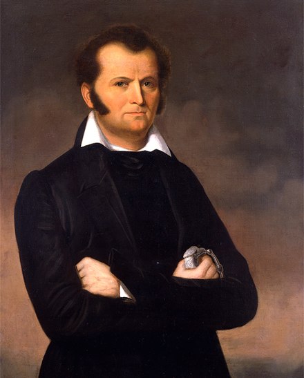
Texas (/ˈtɛksəs/ TEK-səss, locally also /ˈtɛksɪz/ TEK-siz; Spanish: Texas or Tejas, pronounced [ˈtexas]) is the most populous state in the South Central region of the United States. It borders Louisiana to the east, Arkansas to the northeast, Oklahoma to the north, New Mexico to the west, and the Mexican states of Chihuahua, Coahuila, Nuevo León, and Tamaulipas to the south and southwest. Texas has a coastline on the Gulf of Mexico to the southeast. Covering 268,596 square miles (695,660 km2), and with over 30 million residents as of 2023, it is the second-largest U.S. state by both area and population. Texas is nicknamed the Lone Star State for its former status as an independent republic. The Lone Star can be found on the Texas state flag and the Texas state seal. Spain was the first European country to claim and control the area of Texas. Following a short-lived colony controlled by France, Mexico controlled the territory until 1836 when Texas won its independence, becoming the Republic of Texas. In 1845, Texas joined the United States as the 28th state. The state's annexation set off a chain of events that led to the Mexican–American War in 1846. Following victory by the United States, Texas remained a slave state until the American Civil War, when it declared its secession from the Union in early 1861 before officially joining the Confederate States of America on March 2. After the Civil War and the restoration of its representation in the federal government, Texas entered a long period of economic stagnation. Historically, four major industries shaped the Texas economy prior to World War II: cattle and bison, cotton, timber, and oil. Before and after the Civil War, the cattle industry—which Texas came to dominate—was a major economic driver and created the traditional image of the Texas cowboy. In the later 19th century, cotton and lumber grew to be major industries as the cattle industry became less lucrative. Ultimately, the discovery of major petroleum deposits (Spindletop in particular) initiated an economic boom that became the driving force behind the economy for much of the 20th century. Texas developed a diversified economy and high tech industry during the mid-20th century. , it has the most Fortune 500 company headquarters (53) in the United States. With a growing base of industry, the state leads in many industries, including tourism, agriculture, petrochemicals, energy, computers and electronics, aerospace, and biomedical sciences. Texas has led the U.S. in state export revenue since 2002 and has the second-highest gross state product. (Full article...) Selected article -The Rio Grande (/ˌriːoʊ ˈɡrænd/ or /ˌriːoʊ ˈɡrɑːndeɪ/) in the United States or the Río Bravo (del Norte) in Mexico (Spanish pronunciation: [ˈri.o ˈβɾaβo ðel ˈnoɾte]) is one of the principal rivers (along with the Colorado River) in the southwestern United States and in northern Mexico. The length of the Rio Grande is 1,896 miles (3,051 km), making it the 4th longest river in the United States and in North America by main stem. It originates in south-central Colorado, in the United States, and flows to the Gulf of Mexico. The Rio Grande drainage basin (watershed) has an area of 182,200 square miles (472,000 km2); however, the endorheic basins that are adjacent to and within the greater drainage basin of the Rio Grande increase the total drainage-basin area to 336,000 square miles (870,000 km2). The Rio Grande with its fertile valley, along with its tributaries, is a vital water source for seven US and Mexican states, and flows primarily through arid and semi-arid lands. After traversing the length of New Mexico, the Rio Grande becomes the Mexico–United States border, between the U.S. state of Texas and the northern Mexican states of Chihuahua and Coahuila, Nuevo León and Tamaulipas; a short segment of the Rio Grande is a partial state-boundary between the U.S. states of New Mexico and Texas. Since the mid–twentieth century, only 20 percent of the Rio Grande's water reaches the Gulf of Mexico, because of the voluminous consumption of water required to irrigate farmland (e.g. the Mesilla and Lower Rio Grande Valleys) and to continually hydrate cities (e.g. Albuquerque); such water usages are additional to the reservoirs of water retained with diversion dams. 260 miles (418 km) of the river in New Mexico and Texas are designated as the Rio Grande Wild and Scenic River. (Full article...)Selected biography -James Bowie (/ˈbuːi/ BOO-ee) (April 10, 1796 – March 6, 1836) was a 19th-century American pioneer, slave smuggler and trader, and soldier who played a prominent role in the Texas Revolution. He was among the Americans who died at the Battle of the Alamo. Stories of him as a fighter and frontiersman, both real and fictitious, have made him a legendary figure in Texas history and a folk hero of American culture. Bowie was born on April 10, 1796, in Logan County, Kentucky. He spent most of his life in Louisiana, where he was raised and where he later worked as a land speculator. His rise to fame began in 1827 on reports of the Sandbar Fight near present-day Vidalia, Louisiana. What began as a duel between two other men deteriorated into a mêlée in which Bowie, having been shot and stabbed, killed the sheriff of Rapides Parish with a large knife. This, and other stories of Bowie's prowess with a knife, led to the widespread popularity of the Bowie knife. (Full article...)Texas news
Wikinews Texas portal
ListsState symbols
Texas topicsSelected imageCities -El Paso (/ɛl ˈpæsoʊ/; Spanish: [el ˈpaso]; lit. 'the pass' or 'the step') is a city in and the county seat of El Paso County, Texas, United States. The 2020 population of the city from the U.S. Census Bureau was 678,815, making it the 22nd-most populous city in the U.S., the most populous city in West Texas, and the sixth-most populous city in Texas. Its metropolitan statistical area covers all of El Paso and Hudspeth counties in Texas, and had a population of 868,859 in 2020. El Paso stands on the Rio Grande across the Mexico–United States border from Ciudad Juárez, the most populous city in the Mexican state of Chihuahua. The Las Cruces area, in the neighboring U.S. state of New Mexico, has a population of 219,561. On the U.S. side, the El Paso metropolitan area forms part of the larger El Paso–Las Cruces combined statistical area, which has a population of 1,098,541. These three cities form a combined international metropolitan area sometimes referred to as the Paso del Norte or the Borderplex. The region of 2.7 million people constitutes the largest bilingual and binational workforce in the Western Hemisphere. (Full article...)General imagesThe following are images from various Texas-related articles on Wikipedia.
CategoriesSelect [►] to view subcategories
Related pages
Attractions
 Things you can doAssociated WikimediaThe following Wikimedia Foundation sister projects provide more on this subject:
SourcesMore portals | |||||||||||||||||||||||||||||||||||||||||||